  April 2005 NewsletterISSN: 1933-8651For this month's online newsletter, we reproduce below an online version of an article entitled Rediscovering New Philadelphia: Race and Racism on the Illinois Frontier, by Paul A. Shackel, Terrance J. Martin, Joy D. Beasley, and Tom Gwaltney. This article was published in Illinois Antiquity, Vol. 39, Issue 1, pp. 3-7 (March, 2004), and is presented here with permission from the Illinois Association for Advancement of Archaeology, which publishes Illinois Antiquity. An .html version of this article is published below, or you can view a pdf version. Rediscovering New Philadelphia: |
 |
| Figure 1. Location of New Philadelphia |
The During several long weekends in the fall of 2002 and the spring of 2003 the University of Maryland, Illinois State Museum, University of Illinois- Springfield, HistArc Consultants, and the New Philadelphia Association collaborated in a field survey to locate and identify the town of New Philadelphia (Beasley and Gwaltney 2003). This effort, initiated by Vibert White (UIS), and supported by the above-mentioned organizations, is helping to reveal a significant portion of Illinois' historic past and it provides insight into how race and racism can be discovered on the Illinois landscape.
The town was abandoned by the 1940s and all that exists today are a few foundations in fields covered with sod, prairie grass and wheat. Without any visible sign of preexisting landscape features, the research team used historic and topographic maps and aerial photographs to determine the location of the town. Initial deed research (Whitt 2000) indicates that all of the lots were sold many times by both blacks and whites. Census data analysis (King 2003) indicates that as many as 200 people lived in the town in the post-Civil War era. The town existed as an integrated entity into the twentieth century. After the Illinois frontier closed, racism set limits to New Philadelphia expansion. Businessmen from Pike County lobbied to have a new railroad placed adjacent to another community. By 1885 the town was unincorporated, and by the early twentieth century only a few houses survived. Today, all signs of the town have been removed from the landscape and the fields are planted in prairie grass and wheat.
NEW PHILADELPHIAThe founding and incorporation of the town of New Philadelphia in west-central Illinois by Free Frank, a freed African American, in 1836 is both a compelling and heroic story. Historian Juliet Walker's (1983) biography of Free Frank describes that while he was enslaved he also worked in the saltpeter mines of Kentucky when he did not have plantation obligations. He earned enough money to purchase his freedom from his master and eventually traveled westward with his wife and a few of his freed children to Pike County, Illinois. The McWorters were the first settlers in Hadley Township.
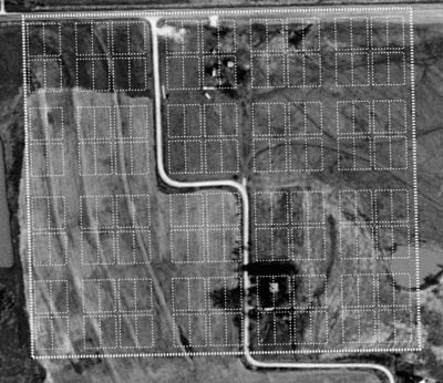 |
| Figure 2. 1836 plat of New Philadelphia overlaid on a recent aerial photograph of the site. (Courtesy, HistArc Consultants, LLC). |
While African Americans developed towns before 1836 (see Cha-Jua 2000), New Philadelphia is the earliest known town incorporated by an African American. Both Euro- Americans and African Americans purchased property in New Philadelphia and moved to the community. The small rural integrated town boomed in the 1860s. Because of Walker's (1983) research, we know a significant amount about Frank McWorter's experience with New Philadelphia from its founding until his death in 1854. The goal of this collaborative New Philadelphia project is to provide a more in-depth social history of the town, documenting the rise of the town from 1836 through its demise during the Jim Crow era. This project is building on Walker's research and will look at the histories of all of the residents of New Philadelphia, describe social relations between blacks and whites through the early twentieth century, and place this work in a larger context of small rural nineteenth- century black and bi-racial towns. Enhancing the story of New Philadelphia will contribute an important episode to our national memory.
The New Philadelphia story is important because it adds a new dimension to the study of black settlement and inter-racial living in the United States. Before the American Civil War, most free blacks lived in urban areas and suffered deteriorating social and economic conditions. They were restricted to few opportunities and often had irregular and/or seasonal employment. "They had a low incidence of property ownership in most cities, and were universally described by contemporary observers as in large part poverty stricken" (Curry 1981:122). Blacks in urban areas increasingly called for reforms. At the same time, the American Colonization Society aggressively promoted the relocation of free blacks to Liberia.
In response to the promotion of resettlement in Africa, during the 1830s the Organized Negro Communities Movement proposed that separate agricultural settlements should be established for free blacks in undeveloped rural areas. The organization also encouraged the migration of African Americans to the western frontiers. Both of these proposals would allow African Americans the opportunity to develop new economic opportunities for themselves (Pease and Pease 1962:19-34).
In 1819 the first manumission colony in Edwardsville, Illinois stood as one of the most prominent settlements of the Organized Negro Communities Movement. The Edwardsville Settlement operated as a paternalistic endeavor by Edward Cole, who freed thirteen slaves and purchased land so that they could develop farms. Other paternalistic settlements developed following Cole's lead, although many of these settlements failed, including Edwardsville. These planned agricultural communities usually consisted of farms too small to be self-sufficient and the communities were undercapitalized (Pease and Pease 1962:23).
Other settlements, however, did succeed. Sundiata Keita Cha-Jua (2000) describes the settlement of Brooklyn, Illinois, founded in 1830 by several black families adjacent to St. Louis, Missouri. Five white settlers platted the area in 1837, and citizens finally incorporated the town after the Civil War. Because of racism and industrialists' unwillingness to establish businesses in the town, Brooklyn struggled financially through the beginning of the twentieth century. In another settlement, Reverend Lewis Woodson believed that African Americans should establish separate communities, separate businesses, and separate churches. His father's settlement in Jackson County, Ohio in 1830 served as a prime example that showed that separate black communities could survive and prosper. By 1838 it was "socially independent" (Miller 1975:315).
Black Codes established before the Civil War often restricted the freedoms of African Americans, and they frequently were left with no choice but to work on farms or perform menial tasks. Although a vacuum created by the expanding frontier allowed people to take risks on entrepreneurial activities, blacks were not always on equal footing with white settlers. Being a free African American in southern Illinois met some resistance from the local populations. For instance, about 50 miles south of New Philadelphia in Alton, Elijah Lovejoy ran his abolitionist newspaper and founded the Illinois Anti-Slavery Society. An angry mob attacked his newspaper in 1837, one year after the founding of New Philadelphia. They killed Lovejoy while he tried to protect his press (Dillon 1961; Beecher 1838; Tanner 1881).
Only thirteen miles east of New Philadelphia in the town of Griggsville, violence broke out after an 1838 anti-slavery meeting. Residents signed a petition calling for the abolition of slavery in Washington, D.C. and for rejecting the admission of Texas into the Union as a slave state. In reaction to this meeting, pro-slavery citizens met at the local grocery and they passed a resolution "that the parties who signed this obnoxious petition should be compelled to erase their signatures from it" (Chapman 1880:516). The pro-slavery mob seized the document and "then waited upon those parties and demanded of them that they should immediately erase their names" (Chapman 1880:516). Hearing this news, the people of Griggsville and the surrounding country confronted the pro-slavery gathering. They said that they "must disband, or else they would be dealt with harshly" (Chapman 1880:516).
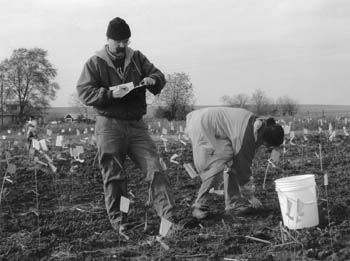 |
| Figure 3. Terrance Martin of the Illinois State Museum and Lisa Winhold, now a graduate student in zoology at Eastern Michigan University, record and collect artifact information (Courtesy, HistArc Consultants, LLC). |
A rural market town like New Philadelphia in the heart of this racial tension could offer African Americans an alternative to isolated rural farmsteads and the hostile environment of urban ghettos, although the town sat less than 25 miles east of the Mississippi River and the slave state of Missouri. While situated in a free state, once the Illinois frontier closed, racism set limits to New Philadelphia's economic expansion (see Davis 1998). In 1853 the Pike County Rail Road Company, made up of prominent farmers and businessmen in the area, met to create a route for a new railroad line, although it would not be built until after the Civil War. The interests of New Philadelphia were not represented on the board. The route for the Hannibal & Naples Railroad came from the east, and if it continued in a direct easterly direction it would have intersected New Philadelphia. Instead, the railroad company routed the line to New Salem about a mile north of New Philadelphia. In order to reach New Salem, the line looped north and around New Philadelphia. When the line reached a point west of New Philadelphia, it swung south to a point directly west of the town, and it again ran in an east to west direction until it reached the town of Barry (Pike County Railroad 1853; Chapman 1880:904; Matteson 1964:9).
While New Philadelphia existed as a small rural town through the 1850s, it boomed in the 1860s as newly freed African Americans joined the community, making a new start in life after emancipation. As a commitment to educating all of the citizens of the community, the town supported an integrated one-room schoolhouse from 1874 until it closed in the 1940s (Matteson 1964:19-20; Pike County Illinois Schools 1996:153). The town population dwindled quickly in the 1870s after the railroad company constructed the line through a more northern town.
New Philadelphia was finally unincorporated in 1885. Oral histories of former residents performed in the early 1960s indicate that an unincorporated New Philadelphia survived as an integrated town into the twentieth century with only a few households (Matteson 1964). Today, nothing remains of the community except a few foundations and a graveyard that contains the headstones of some of the former community residents. The town has all but disappeared from the landscape. New Philadelphia is an archaeological site covered by prairie grass, sod, and wheat. The few exposed foundations serve as a reminder of a great achievement in the African-American experiment, a sojourn toward self-determinism, freedom and the will to exist. The history of the entire town, black and white, from the 1830s through 1920s, waits to be rediscovered with the objective of making this story a part of our national heritage.
THE PEDESTRIAN SURVEYIn 1996 a group of Pike County citizens formed the New Philadelphia Association (NPA) as a non-profit group in order to strive for the preservation of the site. In 2001 they invited the University of Illinois at Springfield (UIS) to provide scholarly oversight for the study of the former community. In turn, the NPA and UIS invited the University of Maryland (UM) and the Illinois State Museum (ISM) to organize an archaeological survey to find and document the exact location of the former town of New Philadelphia in order to help broaden the scope of research.
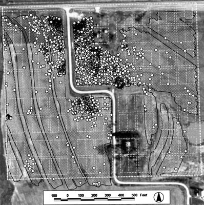 |
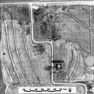
| Figure 4. Map showing the distribution of all historic artifacts found in the New Philadelphia pedestrian survey. (Courtesy, HistArc Consultants, LLC). [Click on the image above to view a larger version] |
In the fall 2002 and spring 2003, the collaborative project to rediscover New Philadelphia began with a pedestrian archaeological survey. The survey had two goals; 1) to determine that archaeological resources exist at the New Philadelphia site, and 2) to identify surface concentrations that could co-register with the known 1836 New Philadelphia plat (Figure 2). These areas of concentration provide important clues that indicate the town lots occupation and functions. Census and deed data shows that both domestic and work functions occurred within the town's boundaries. Oral histories also indicate that New Philadelphia stood as a small hamlet into the early twentieth century. The results of the survey provide information that will guide further archaeological explorations.
Prior to the survey the archaeology team decided to have lands that have been under agriculture plowed and disked. While the local farmers practice no-till agriculture today, two local farmers still owned a moldboard plow and they helped with the process. The plowing broke up the prairie grasses and sod, which covered areas formerly under cultivation. This process generally provided greater than 75 per cent ground visibility over the majority of the plowed field. Subsequent precipitation and weathering improved artifact visibility. The plowing allowed for about 26.5 acres (10.6 ha), or approximately 63 per cent of the 42-acre (16.8 ha) site, to be exposed (Beasley and Gwaltney 2003).
Two areas were not plowed. The first, in the northern portion of the site, contained some historic foundations and local informants claimed that the area was never plowed (Figure 2). The archaeology team did not want to impact areas that may not have been previously plowed, so we decided not to plow and disk this area. Also, at the time of the survey the project did not receive permission to perform survey work on property situated in the southern portion of the site. Plowing did not occur where terracing had occurred, in treecovered areas, and in roadways (Beasley and Gwaltney 2003).
The volunteer effort for the New Philadelphia pedestrian survey was coordinated by University of Illinois-Springfield and the Illinois State Museum. These institutions coordinated the efforts of 31 student volunteers from UIS, Illinois College, Hannibal-LaGrange College, and Lincoln Land Community College over the three separate weekend expeditions. Members of the New Philadelphia Association provided necessary logistical support. Archaeologists conducted the survey over three long weekends: October 11-14 and November 8-10, 2002, and March 14-16, 2003.
The volunteers and archaeologists formed a line at the edge of a plowed field, with each team member spaced approximately 5 ft. (1.5m) apart. The survey team systematically walked over the survey area in transects, marking each historic period and prehistoric artifact visible on the ground with a flag. Once a transect or survey area had been completed, the teams regrouped and systematically surveyed the adjacent transect or survey area. The process was repeated until the team surveyed the entire project area.
Archaeologists then collected the flagged artifacts (Figure 3). Working in teams of two to four members, archaeologists systematically collected each flagged artifact and accounted for the artifacts on a log sheet. Archaeologists then assigned a unique number to the flag marking the collected artifact. These flagged "targets" were then surveyed sequentially using an electronic total station and each target's spatial location was recorded with an electronic data recorder. The site-specific spatial location information was annotated with the artifact's unique provenience ID assigned by the artifact collection team. The spatial location and annotation recorded for each target were downloaded from the data record to a computer for translation to and analysis by geographic information system (GIS) (Beasley and Gwaltney 2003).
RESULTSA total of 7,073 historic period and prehistoric artifacts were identified, collected, and mapped over the 10-day survey. Domestic artifacts include small ceramic sherds, bottles, drinking vessels, smoking pipes, buttons, doll parts, horseshoes, miscellaneous iron objects and small animal remains. Architectural materials consist of brick fragments, nails, and window glass. At the Illinois State Museum the artifacts have been cleaned and labeled. About 83 per cent (5,895 items) are historic period artifacts and 15 per cent (1,076 items) are prehistoric artifacts. About two per cent, or 102 artifacts, could not be specified as cultural or non-cultural. At this point in the analysis process the materials have been identified into nine broad categories. They include historic period ceramics (2,320 items, 32%), curved glass (1,031 items, 15%), buttons and toy parts (28 items, 0.4%), flat glass (1,093 items, 15%), brick/plaster/mortar (328 items, 5%), nails/spikes (185 items, 2.6%), other historic period artifacts (910 items, 13%), prehistoric artifacts (1,076 items, 15%), and unidentified artifacts (102 items, 2%) (Beasley and Gwaltney 2003).
 |
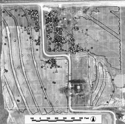
| Figure 5. A distribution of domestic artifacts. The squares are doll parts, the hexagons are buttons, the triangles are curved glass, and the circles are ceramics. (Courtesy, HistArc Consultants, LLC). [Click on the image above to view a larger version] |
The survey results provide a general sense of the areas settled at New Philadelphia. In addition, the historic period materials are found in dense concentrations and indicate the location and remains of domestic houses and commercial enterprises (Figure 4). All of the historic period household sites appear to cluster near the center of town on about 25 per cent of the land close to the town's major road. This concentration is located on the highest elevation in town.
While Frank McWorter lived on a parcel just north of New Philadelphia, it is clear that he and his family kept close ties with the town. His son, Squire McWorter, lived on the lot that is indicated by the southernmost cluster of artifacts and just south of the road running in an east-west direction (Figures 5 and 6). Other black and white families are known to have lived along the main road in the northern portion of the town along the road running in a north-south direction. Many of the other lots were never settled, although deed records indicate that every lot changed hands at least several times over the century. McWorter planned on building a church on the property, but that idea never materialized. It appears that others purchased New Philadelphia lots and used the lands as extensions of their houses for gardening and/or other utility functions. We can also assume that others purchased the lands to speculate on the arrival of the railroad. When the road did not arrive, the town was unincorporated and the eastern section of the town was returned to agriculture.
 |
| Figure 6. A distribution of architectural artifacts. The red squares are brick/plaster/mortar, the blue triangles are flat glass, and the yellow circles are nails and spikes. (Courtesy, HistArc Consultants, LLC). [Click on the image above to view a larger version] |
The archaeological survey at New Philadelphia provides a good starting point for future in-depth excavations and analysis. One of the goals of this project is to list the New Philadelphia site on the National Register of Historic Places. National Register status will allow this collaborative effort to pursue additional avenues of funding for further research. The analysis will also provide information so that the project can plan a more in-depth and long-term archaeology project (Figure 7). Many studies in African-American archaeology and material culture have been concerned with the preemancipation era. An archaeological study of New Philadelphia will provide the opportunity to examine the development of an integrated community on the western frontier during the pre- and post-emancipation eras. Racism probably influenced the social and economic interactions between residents within the community as well as with people who lived outside of the town. The archaeological material from New Philadelphia will reveal aspects of life there that cannot be found in historical records. It will be important to examine the material culture record and the social history of the town and look for variability in the archaeological record. We may see how the material culture may have changed as racism influenced the development of New Philadelphia and the everyday lives of its inhabitants. The town's rediscovery by a dedicated team of archaeologists and historians, and the analysis and reporting of these discoveries, helps show how its story is an important part of our national heritage.
The National Science Foundation's Research Experiences for Undergraduates (NSF-REU) has funded three summers of excavations and laboratory work for this project. Our goal is to incorporate students in the research design, data collection, and analysis of the archeological materials. The University of Maryland will be the host institution with substantial cooperation from the Illinois State Museum and the University of Illinois at Urbana- Champaign. The New Philadelphia Association, a local non-profit group, and the University of Illinois at Springfield will provide support. This cooperative program brings various professionals and community members together, and it will help enhance the quality and availability of undergraduate research experiences.
The NSF-REU program will accept 9 students for 10 weeks for the summers of 2004-2006 (For an application follow the links http://www.heritage.umd.edu). We will recruit a diversified pool of talented students who will participate in all aspects of the project. A significant proportion of the students will come from outside the host institution. Our goal is to increase the participation of women and underrepresented minorities. Regional colleges and universities will be another of our target areas since many of these schools have limited research programs.
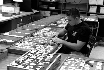 |
| Figure 7. Greg Butterfield of Illinois College working on the artifacts from the New Philadelphia site at the ISM Research and Collections Center. (Courtesy, Illinois State Museum). |
The program will be divided into three components. First, a one-week orientation and background session that includes the geophysical testing of archaeological sites; a four week archaeology field season collecting data; a five week session at ISM scientifically analyzing material culture and archaeobiological data. Students will work in a collaborative effort while also receiving mentorship from an interdisciplinary team of professionals. Students will receive training in archaeological field methods, artifact identification, and cataloguing, as well as in faunal and floral analysis.
ACKNOWLEDGEMENTSMany people and organizations are responsible for the success of this survey. While Paul Shackel (Center for Heritage Resource Studies, University of Maryland) coordinated the project, HistArc carried out the field survey under the direction of Joy Beasley and Tom Gwaltney in October and November 2002 and March 2003. Their dedication and hard work made the field survey an overwhelming success. The National Park Service now employs Beasley. Illinois State Museum (Terry Martin) and the University of Illinois at Springfield (Vibert White and Lynn Fisher) coordinated the volunteer effort and also provided logistical support for the project. The volunteers for the field survey included: Heather Bangert, Erin Brand, Greg Butterfield, Roberta Codemo, Jessica Dix, Brandon Eckhoff, Sarah Edmiston, Cinda Farris, James Farris, Sridhar Gaddam, Justina Garcia, Jeff Gheens, Tammy Hamilton, Michelle Huttes, Fran Knight, Ellen Marr, Carol McCartney, Norvel McIntyre, Donald McWilliams, Elizabeth Netherton, Terry Ransom, Lisa Schnell, Julie Senger, Tim Sorrill, Mary Thomas, Sreekanth Vudumula, Debbie White, Heater Wichens, Seth Wilson, Lisa Winhold, Linda Woods, and Carolyn Wrightam.
The laboratory work was conducted at the Illinois State Museum and supervised by Terry Martin. These volunteers included: Jim Farris, Roberta Codemo, Greg Butterfield, Don McWilliams, Tim Sorrill, Jennifer Schwarz, Carolyn Wrightam, Lisa Winhold, Tiffany Winhold, Julie Senger, Brianne Senger, Mary Thomas, and Kati Fay. Jim Farris and Debbie White have worked with Michael Wiant and Lynn Fisher on the New Philadelphia lithic assemblage. Our thanks to Mayor Pat Syrcle and the community of Barry, Illinois for making us welcome. Roger Woods helped with the preparation of the site before the survey. Our deep appreciation goes to Marvin and Pat Likes. Marvin and his survey team at Likes Land Surveyors provided support and they laid out the town grid from the historic plat. Carolyn Dean was stationed at the tent ensuring that the archaeology team had all that we need. Larry and Natalie Armistead opened their homes to the survey team. We appreciate their willingness to allow us to survey their property. We extend a special thanks to Mr. Phil Bradshaw, president of the New Philadelphia Association. He supplied logistical support and ensured that all of our needs were met for the survey.
REFERENCESBeecher, Edward
1838 Narratives of the Riots at Alton: In Connection with the Death of Rev. Elijah P. Lovejoy. George Holton, Alton, IL.
Beasley, Joy and Tom Gwaltney
2003 New Philadelphia Project Field Survey: Interim Report. Phase I Archaeology at the Historic Town of New Philadelphia, Illinois. HistArc Consultants, LLC, Baltimore, MD.
Cha-Jua, Sundiata Keita
2000 Americas First Black Town, Brooklyn, Illinois, 1830-1915. University of Illinois Press, Urbana, IL.
Chapman, Charles C.
1880 History of Pike County, Illinois. C.C. Chapman, Chicago, IL.
Curry, Leonard P.
1981 The Free Blacks in Urban America, 1800-1850: The Shadow of the Dream. University of Chicago Press, Chicago, IL.
Davis, James E.
1998 Frontier Illinois. Indiana University Press, Bloomington, IN.
Dillon, Merton L.
1961 Elijah P. Lovejoy: Abolitionist Editor. University of Illinois Press, Urbana, IL.
King, Charlotte
2003 Passed by Time: America's All-Black Towns. Honor's Thesis. Department of Anthropology. University of Maryland, College Park, MD.
Matteson, Grace
1964 "Free Frank" McWorter and the "Ghost Town" of New Philadelphia, Pike County, Illinois. Pike County Historical Society, Pittsfield, IL.
Miller, Floyd J.
1975 The Search for Black Nationality: Black Emigration and Colonization, 1787-1863. University of Illinois Press, Urbana, IL.
Pease, William and Jane Pease
1962 Organized Negro Communities: A North American Experiment. Journal of Negro History 47(1):19-34.
Pike County Railroad Company
1853 Record of the Pike County Rail Road Company. Record no. SC2287. Illinois State Historical Society, Springfield, IL.
Pike County Illinois Schools
ca. 1996 Pike County Illinois Schools, 1823- 1995: History and Pictures. Pike County Historical Society, Pittsfield, IL.
Tanner, Henry
1881 The Martyrdom of Lovejoy -- An Account of the Life, Trials, and Perils of Rev. Elijah P. Lovejoy Who was Killed by a Pro-Slavery Mob at Alton, Illinois the Night of November 7, 1838. Fergus Printing Co., Chicago.
Walker, Juliet E. K.
1983 Free Frank: A Black Pioneer on the Antebellum Frontier. University Press of Kentucky, Lexington, KY.
Whitt, Robin
2000 New Philadelphia: A Case Study of a Free African-American Settlement and the Underground Railroad in Pike County, Illinois. Honor's Thesis. Department of Anthropology. University of Maryland, College Park, MD.
Paul A. Shackel is Professor of Anthropology and Director of the Center for Heritage Resource Studies at the University of Maryland; Terrance J. Martin, Curator of Anthropology, Illinois State Museum; Joy D. Beasley, Cultural Resource Program Manager, Monocacy National Battlefield, National Park Service; and Tom Gwaltney, President, arGIG Consultants, LLC.